
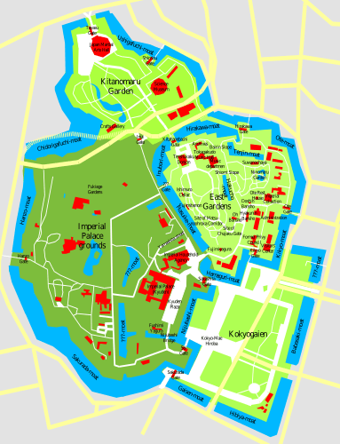
Image: Imperial Palace Tokyo Map

Description: This is the SVG version of Image:Imperial Palace Tokyo Map.sxd, checked with a GoogleMaps Satellite Image and corrected for proportions. Notes by the original authoru: This is a map of the Imperial Palace in Tokyo (Kokyo), drawn by me based on various sources and satelite pics. Disclaimer: Many locations are only approximate, not all streets, buildings, and waterways are shown, I give no guarantee for accuracy, use at your own risk.
Title: Imperial Palace Tokyo Map
Credit: Imperial_Palace_Tokyo_Map.png
Author: Imperial_Palace_Tokyo_Map.png: User:Chris 73 derivative work: ExplicitImplicity (talk)
Usage Terms: Creative Commons Attribution-Share Alike 3.0
License: CC BY-SA 3.0
License Link: http://creativecommons.org/licenses/by-sa/3.0
Attribution Required?: Yes
Image usage
The following page links to this image:
