
Image: IrelandBaronies1899Map (Dublin cropped)
No higher resolution available.
IrelandBaronies1899Map_(Dublin_cropped).png (311 × 419 pixels, file size: 70 KB, MIME type: image/png)
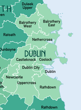
Description: Map of the Baronies of Ireland in 1846. Source data: Ordnance Survey of Ireland: Baronies 2011 (OSI Opendata https://data-osi.opendata.arcgis.com/). Ordnance Survey of Northern Ireland Townlands (OSNI Opendata https://www.nidirect.gov.uk/services/osni-open-data-portal). National University of Ireland Galway Barony Maps (http://archives.library.nuigalway.ie/memorial/memorial-atlas.html).
Title: IrelandBaronies1899Map (Dublin cropped)
Credit: Own work
Author: XrysD
Usage Terms: Creative Commons Attribution-Share Alike 4.0
License: CC BY-SA 4.0
License Link: https://creativecommons.org/licenses/by-sa/4.0
Attribution Required?: Yes
Image usage
The following 4 pages link to this image:

All content from Kiddle encyclopedia articles (including the article images and facts) can be freely used under Attribution-ShareAlike license, unless stated otherwise.
.png)