
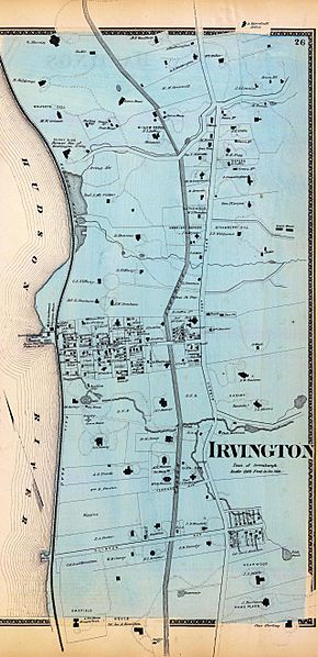
Image: Irvington 1868 map

Size of this preview: 290 × 598 pixels. Other resolutions: 116 × 240 pixels | 2,557 × 5,277 pixels.
Original image (2,557 × 5,277 pixels, file size: 2.97 MB, MIME type: image/jpeg)
Description: The Irvington section of a map of Hastings, Dobbs Ferry and Irvington, New York, 1868
Title: Irvington 1868 map
Credit: NYPL Digital Gallery at digitalgallery.nypl.org
Author: F.W. Beers; cropped by Beyond My Ken (talk) 21:44, 30 June 2010 (UTC)
Usage Terms: Public domain
License: Public domain
Attribution Required?: No
Image usage
There are no pages that link to this image.

All content from Kiddle encyclopedia articles (including the article images and facts) can be freely used under Attribution-ShareAlike license, unless stated otherwise.