
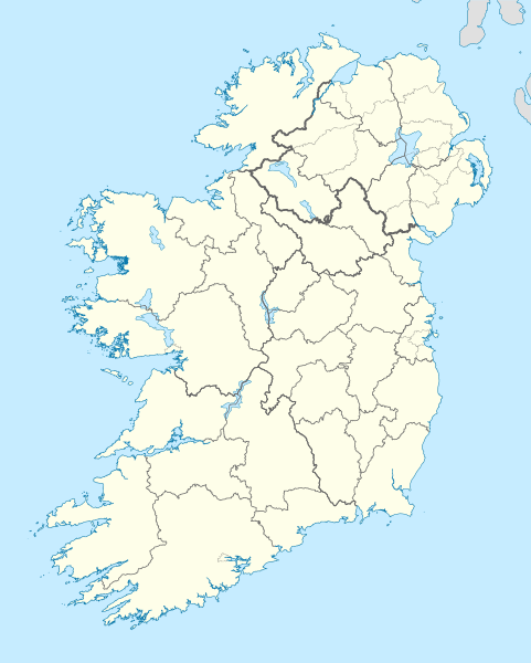
Image: Island of Ireland location map

Size of this PNG preview of this SVG file: 481 × 599 pixels. Other resolution: 192 × 240 pixels.
Original image (SVG file, nominally 1,450 × 1,807 pixels, file size: 1.96 MB)
Description: The island of Ireland, showing international border between Ireland and Northern Ireland, traditional provinces, traditional counties, and local authority areas in Ireland and Northern Ireland.
Title: Island of Ireland location map
Credit: Ireland_location_map.svg Ordnance Survey of Northern Ireland Ordnance Survey Ireland Openstreetmap
Author: Ireland_location_map.svg: NordNordWest derivative work: Nilfanion
Usage Terms: Creative Commons Attribution-Share Alike 3.0
License: CC BY-SA 3.0
License Link: https://creativecommons.org/licenses/by-sa/3.0
Attribution Required?: Yes
Image usage
More than 100 pages link to this image. The following list shows the first 100 page links to this image only. A full list is available.
- Achillbeg
- Ardoileán
- Bartragh Island
- Beginish Island
- Beiginis
- Bere Island
- Bull Island
- Burr Point
- Caher Island
- Canon Island
- Cape Clear Island
- Capel Island
- Church Island (Lough Gill)
- Clare Island
- Collanmore Island
- Colt Island
- Coney Island, County Sligo
- Crone Woods
- Dalkey Island
- Deenish Island
- Deer Island (Ireland)
- Dinish Island
- Dorinish
- Dursey Island
- Dún Ailinne
- Eagle Island, County Mayo
- Eighter Island
- Fenit Island
- Fota Island
- Garinish Island (County Kerry)
- Garnish Island
- Glashedy
- Glenmalure
- Gola Island
- Gorumna
- Great Blasket Island
- Great Island
- Haulbowline
- Heir Island
- Hill of Uisneach
- Horse Island, County Cork
- Illanmaster
- Illauneeragh
- Illauneeragh West
- Inch Island
- Inchaghaun
- Inchamakinna
- Inchcleraun
- Inchydoney
- Inis Cealtra
- Inis na Bró
- Inish Turk Beg
- Inishbiggle
- Inishbofin, County Donegal
- Inishbofin, County Galway
- Inishcoo
- Inishcorker
- Inishdalla
- Inishdooey
- Inishfarnard
- Inishfree
- Inishglora
- Inishkeel
- Inishloe
- Inishlyre
- Inishmacowney
- Inishmeane
- Inishmurray
- Inishnee
- Inishsirrer
- Inishtooskert
- Inishturk
- Inishturk South
- Inishvickillane
- Innisfallen Island
- Island Eddy
- Lambay Island
- Lapp's Island
- Little Island, Waterford
- Little Skellig
- Long Island, County Cork
- Mason Island
- Maínis
- Mullinhassig Wood & Waterfalls, Aghavrin
- Mutton Island
- Mutton Island, County Galway
- Nendrum Monastery
- Oileán Ruaidh
- Omey Island
- Owey Island
- Puffin Island (County Kerry)
- Rathlin O'Birne
- Roancarrigmore
- Rocky Island (Cork)
- Rossmore Island
- Rotten Island
- Rutland Island, County Donegal
- Sandycove Island
- Scariff Island
- Shenick Island

All content from Kiddle encyclopedia articles (including the article images and facts) can be freely used under Attribution-ShareAlike license, unless stated otherwise.