
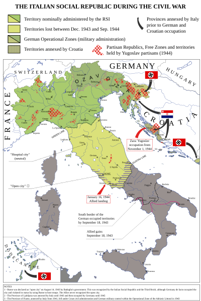
Image: Italian-social-republic-and-civil-war

Description: Map of Italy during the Civil War, focusing on the Italian Social Republic
Title: Italian-social-republic-and-civil-war
Credit: Own work - Bibliography: Atlante storico della Resistenza italiana by L. Baldissara, Bruno Mondadori, 2000; Storia della Guerra Civile in Italia 1943-1945 by Giorgio Pisanò, FPE, 1965-'67; Breve storia della Resistenza Italiana, FIVL, Edizioni Civitas, 1990. About OZAK: Salò-Berlino, l'alleanza difficile by Nicola Cospito, Hans W. Neulen, Mursia and this map; about Rome "open city" occupied by Germans and not capital of RSI, Renzo De Felice, Mussolini, l'Alleato. La guerra civile, Einaudi, p. 373. About German and Allies positions in Southern Italy at September 18, 1943: http://www.westpoint.edu/, Harper Collins Atlas of the Second World War, Storia della Seconda guerra mondiale, vol. 4, Rizzoli-Purnell. About the territories held by Yugoslav partisans in Dalmazia and in the Province of Ljubljana see http://upload.wikimedia.org/wikipedia/commons/f/f8/Oslobo%C4%91ena_teritorija_septembra_1944.jpg . About the British-Yugoslav occupation of Lissa (Vis), see: "Chronology and Index of the Second World War, 1938-1945" (The Royal Institute of International Affairs) and "Tito, Mihailović, and the Allies, 1941-1945" (Walter R. Roberts). About the names of cities see http://images.nationmaster.com/images/motw/historical/italy_1921.jpg Original map realized for the congress “Agricoltura e vita quotidiana nella RSI” (Salò, Italy, October 2004) - new version updated and remedied on Storia in Rete n. 49-50 (released in CC 3.0 SA by).
Author: Emanuele Mastrangelo
Usage Terms: Creative Commons Attribution-Share Alike 4.0
License: CC BY-SA 4.0
License Link: https://creativecommons.org/licenses/by-sa/4.0
Attribution Required?: Yes
Image usage
The following page links to this image:
