
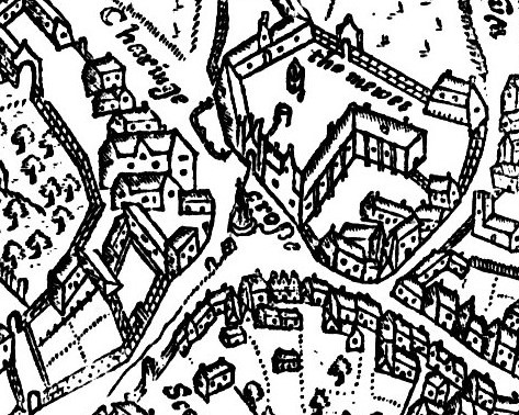
Image: John Norden's Map of Westminster - Charing Cross
No higher resolution available.
John_Norden's_Map_of_Westminster_-_Charing_Cross.jpg (473 × 378 pixels, file size: 154 KB, MIME type: image/jpeg)
Description: John Norden's Map of Westminster, 1593, engraved by Pieter Van den Keere. Original size 9.5 x 6.75 inches, published in Norden's "Middlesex", dated 1593. Norden was born c. 1548, and was made Surveyor of His Majesty's Woods in 1609. Detail of Charing Cross and surrounding area. The map is oriented with north-west to the top: Whitehall is to the bottom left, and the Strand to the bottom right.
Title: John Norden's Map of Westminster - Charing Cross
Credit: File:John Norden's Map of Westminster Large version.jpeg
Author: John Norden, 1593
Usage Terms: Public domain
License: Public domain
Attribution Required?: No
Image usage
The following 2 pages link to this image:

All content from Kiddle encyclopedia articles (including the article images and facts) can be freely used under Attribution-ShareAlike license, unless stated otherwise.