
Image: John Wayne Pioneer Trail - east end of Iron Horse park

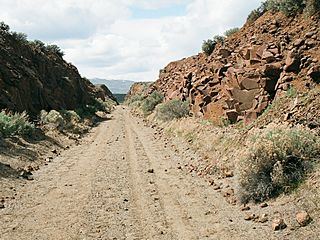
Description: For use with the John Wayne Pioneer Trail article. The trail follows the former roadbed of the w:Chicago, Milwaukee, St. Paul and Pacific Railroad for 300 miles across two-thirds of Washington from the western slopes of the w:Cascade Mountains to the Idaho border. The Chicago, Milwaukee, St. Paul and Pacific Railroad right-of-way was acquired by Washington state and is used as a non-motorized recreational trail managed by the Washington State Parks and Recreation Commission and by the Washington State Department of Natural Resources. State legislation "railbanked" the corridor with provisions that allow for the reversion to rail usage in the future. The 100-mile portion from Cedar Falls (near North Bend) to the Columbia River just south of Vantage has been developed and is managed as the Iron Horse State Park. This photo is taken in a rail cut toward the western end of Iron Horse State Park just south of Vantage.
Title: John Wayne Pioneer Trail - east end of Iron Horse park
Credit: self-made - photo taken and edited by uploader
Author: Williamborg
Permission: All rights released
Usage Terms: Public domain
License: Public domain
Attribution Required?: No
Image usage
The following page links to this image:
