
Image: Johnston et al. Reconnoissances (sic.) of Routes from San Antonio de Bexar to El Paso del Norte 1849 (1850) UTA
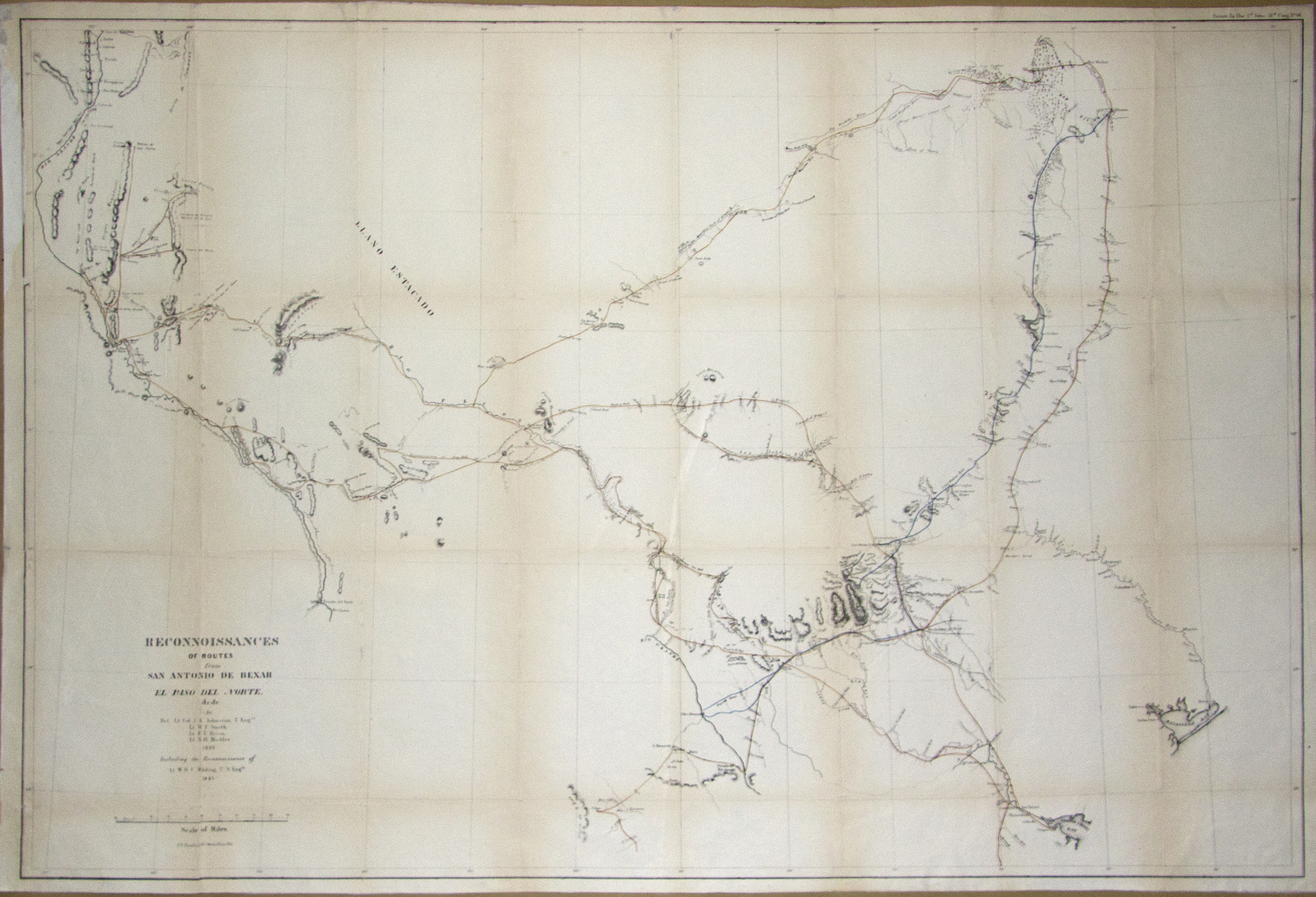
Description: Following the U.S. War with Mexico, the Army reconnoitered, located and established trails, and conducted scientific surveys in order to defend and consolidate the new state of Texas and the newly acquired territories and facilitate travel and communications. This large, minutely-detailed, lithographed folding map is a compilation of several surveys made in 1849 at the orders of General William Jenkins Worth. Gen. Worth briefly commanded the Eighth Military District, comprising Texas, before dying of cholera in San Antonio on May 7 that year. The surveys were led by U.S. Army Topographical Engineers Brevet Colonel Joseph E. Johnston (the future Confederate General) and Lieutenants W. F. Smith, F. T. Bryan, N. H. Michler, and W. H. C. Whiting. The compiled map included only topographical features directly observed by the U.S. military surveyors themselves. It stretches from Corpus Christi, Matagorda Bay, to Preston and Fort Washita in present Oklahoma and from the Rio Grande valley in western Texas and New Mexico east to Matagorda Bay. Of particular interest to the military was the so-called "Upper Road" first blazed earlier that year by the federal Indian Agent for Texas, Robert S. Neighbors, and former Ranger, John S. "Rip" Ford, together with Indian guides. This led from the head of the Concho River (near present San Angelo and located at the center of the map) west across the Pecos at Horsehead Crossing, then past the Davis Mountains and Carizzo Pass (near present Van Horn, Texas) to El Paso. Also that year Captain Randolph B. Marcy guided by a Comanche named Manuel and the Delaware Black Beaver had cut east from Dona Ana past the Hueco Tanks and Guadalupe Mountains to Delaware Creek and the Pecos River. Marcy's route, barely acknowledged on this map, then heads east, northeast from the Pecos to the "Big Springs" of the Colorado River to the Red River in the north. Another route of interest was the "Lower Road", discovered by Whiting and Smith, leading from San Antonio past the Rio Frio west to the San Pedro then up the Pecos near Horsehead Crossing and then over the present Fort Davis area and along the Rio Grande to El Paso. A blue line stretches from the Rio Grande in the south to Preston on the Red River in the north, connecting newly-established Forts Duncan (near present Eagle Pass), Inge (near present Uvalde), Lincoln (camp), Martin Scott (near Fredericksburg), Croghan (near Burnet), Gates (near present Gatesville), and Worth. (This is believed to be the first printed map to show Fort Worth, established on June 6, 1849). These forts protected the settlements along the north-south road just to the east. Originally, the earlier north-south road to the east developed along an earlier line of trading posts, forts, and settlements established during the Republic of Texas. This eastern road stretched from San Antonio through New Braunfels, San Marcos, Manchac's Spring, Austin, Waco Village, Navarro, Dallas, to Preston and Fort Washita in Indian Territory which roughly corresponds to parts of today's U.S. Interstate 35 and Highway 75. Portions from Austin north to Fort Inglish (near present Bonham) and Fort Towson in Indian Territory were known as Cooke's Military Road (blazed in 1840-1841 by Republic of Texas Army Colonel William Gordon Cooke), but after trader Holland Coffee developed the town of Preston (now under Lake Texhoma) on the Red River, the portion from Dallas (established in 1841) north became known as "Preston Road" (completed in 1843).
Title: Reconnoissances [sic] of routes from San Antonio De Bexar to El Paso Del Norte, & cc., & cc. / by Bvt. Lt. Col. J.E. Johnston, T. Eng'rs., Lt. W.f. Smith, Lt. F.T. Bryan, Lt. N.H. Michler, including the reconnoissance [sic] of Lt. W.H.C. Whiting, U.S. Eng'n. 1849
Credit: UTA Libraries Cartographic Connections: map / text
Author: Joseph E. Johnston
Usage Terms: Public domain
License: Public domain
Attribution Required?: No
Image usage
The following page links to this image:

_of_Routes_from_San_Antonio_de_Bexar_to_El_Paso_del_Norte_1849_(1850)_UTA.jpg)