
Image: KC metro map

Size of this PNG preview of this SVG file: 331 × 148 pixels. Other resolution: 320 × 143 pixels.
Original image (SVG file, nominally 331 × 148 pixels, file size: 65 KB)
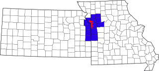
Description: The 15-county Kansas City Metropolitan Area, with the approximate city limits of Kansas City, Missouri in red and counties in blue. SVG version based on File:Kansas city metro counties.jpg
Title: KC metro map
Credit: Own work
Author: Zieben007
Usage Terms: Creative Commons Attribution-Share Alike 3.0
License: CC BY-SA 3.0
License Link: http://creativecommons.org/licenses/by-sa/3.0
Attribution Required?: Yes
Image usage
The following page links to this image:

All content from Kiddle encyclopedia articles (including the article images and facts) can be freely used under Attribution-ShareAlike license, unless stated otherwise.