
Image: Katama or Edgartown Airfield

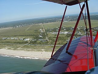
Description: Aerial view of Katama (Edgartown) airfield in Edgartown, MA. Photo shows the airfield on the left and Katama Farm on the right. South Beach is at the bottom of the photo. The road running vertically in the center of the photo is Mattakesett Way, separating the airfield on the left and Katama Farm on the right. The Katama Farm and Katama Airfield are protected in perpetuity. The grass airfield, maintained as a grassy field by periodic burning of small sections, hosts one of the largest collections of endangered plant and animal species in the Commonwealth of Massachusetts.
Title: Katama or Edgartown Airfield
Credit: Own work
Author: User:Rfgagel
Usage Terms: Public domain
License: Public domain
Attribution Required?: No
Image usage
The following page links to this image:
