
Image: LIRR map 1876

Size of this PNG preview of this SVG file: 800 × 475 pixels. Other resolution: 320 × 190 pixels.
Original image (SVG file, nominally 1,152 × 684 pixels, file size: 532 KB)
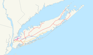
Description: Map of the rail network owned by the Long Island Rail Road in 1876, just after consolidation. The original LIRR is red, the Southern Railroad is orange, the Flushing and North Side Railroad is purple, and the Central Railroad is blue. A standard North American Lambert conformal conic projection was used.
Title: LIRR map 1876
Credit: Own work using public domain GIS data: NORTAD for boundaries 2006 National Transportation Atlas Database for U.S. rail lines
Author: User:NE2
Usage Terms: Public domain
License: Public domain
Attribution Required?: No
Image usage
The following page links to this image:

All content from Kiddle encyclopedia articles (including the article images and facts) can be freely used under Attribution-ShareAlike license, unless stated otherwise.