
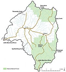
Image: Little Blackfoot River watershed - Montana

Size of this preview: 556 × 600 pixels. Other resolutions: 222 × 240 pixels | 1,429 × 1,542 pixels.
Original image (1,429 × 1,542 pixels, file size: 280 KB, MIME type: image/jpeg)
Description: Map showing the Little Blackfoot River in Montana in the United States, along with tributary rivers and streams that form its watershed. Areas which are part of the Helena National Forest are shown in light green.
Title: Little Blackfoot River watershed - Montana
Credit: http://www.epa.gov/waters/tmdldocs/41463_Master.pdf
Author: Kusnierz, Lisa; Brumm, Peter; Starr, Banning; Makus, Erik (December 2011). Little Blackfoot River Watershed TMDLs and Framework Water Quality Improvement Plan. Washington, D.C.: U.S. Environmental Protection Agency. page 5--4.
Usage Terms: Public domain
License: Public domain
Attribution Required?: No
Image usage
The following page links to this image:

All content from Kiddle encyclopedia articles (including the article images and facts) can be freely used under Attribution-ShareAlike license, unless stated otherwise.