
Image: LocatieSalland
No higher resolution available.
LocatieSalland.png (280 × 130 pixels, file size: 6 KB, MIME type: image/png)
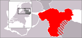
Description: Map of the eastern Netherlands giving the location of Salland within the province of Overijssel. Other parts of Overijssel are shaded dark grey; other parts of the Netherlands, light grey. Germany lies to the east, shaded white.
Title: LocatieSalland
Credit: Transferred from en.wikipedia to Commons. Original based upon PD image File:LocatieTwenterand.png.
Author: Cwoyte at English Wikipedia
Usage Terms: Public domain
License: Public domain
Attribution Required?: No
Image usage
The following page links to this image:

All content from Kiddle encyclopedia articles (including the article images and facts) can be freely used under Attribution-ShareAlike license, unless stated otherwise.