
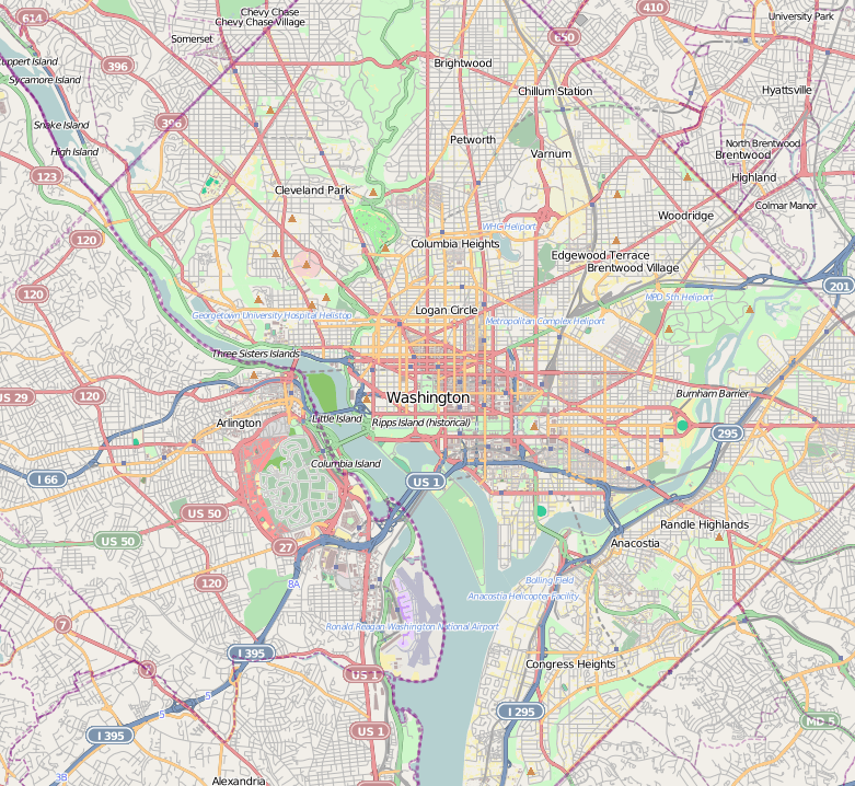
Image: Location map District of Columbia street
Description: Map of Washington D.C. Geographic limits of the map: N: 38.9735° S: 38.8188° W: -77.1446° E: -76.9283° This file is licensed under the Creative Commons Attribution-Share Alike 2.0 Generic license. You are free: to share – to copy, distribute and transmit the work to remix – to adapt the work Under the following conditions: attribution – You must attribute the work in the manner specified by the author or licensor (but not in any way that suggests that they endorse you or your use of the work). share alike – If you alter, transform, or build upon this work, you may distribute the resulting work only under the same or similar license to this one. http://creativecommons.org/licenses/by-sa/2.0 CC BY-SA 2.0 Creative Commons Attribution-Share Alike 2.0 truetrue
Title: Location map District of Columbia street
Credit: OpenStreetMap
Author: Dr. Blofeld
Usage Terms: Creative Commons Attribution-Share Alike 2.0
License: CC BY-SA 2.0
License Link: http://creativecommons.org/licenses/by-sa/2.0
Attribution Required?: Yes
Image usage
The following 69 pages link to this image:
- Adams Memorial (Saint-Gaudens)
- Adas Israel Congregation (Washington, D.C.)
- Arlington Forest Historic District
- Arlington Heights Historic District
- Arlington Village Historic District (Arlington, Virginia)
- Ashton Heights Historic District
- Aurora Highlands Historic District
- Battery Garesche
- Buckingham Historic District
- Camp Barry
- Carter Barron Amphitheatre
- Charles Richard Drew House
- Cherrydale Volunteer Fire House
- Children's Country Home
- Colonial Village (Arlington, Virginia)
- Columbia Forest Historic District
- Convent de Bon Secours
- Fort Albany (Arlington, Virginia)
- Fort Bunker Hill
- Fort C. F. Smith (Arlington, Virginia)
- Fort Corcoran
- Fort DeRussy (Washington, D.C.)
- Fort Ethan Allen (Arlington, Virginia)
- Fort Lincoln (District of Columbia)
- Fort Marcy (Virginia)
- Fort Marcy Park
- Fort Myer
- Fort Reynolds (Virginia)
- Fort Runyon
- Fort Saratoga
- Fort Scott (Arlington, Virginia)
- Fort Slemmer
- Fort Slocum (Washington, D.C.)
- Fort Stevens (Washington, D.C.)
- Fort Sumner (Maryland)
- Fort Thayer
- Fort Totten Park
- Fort Woodbury
- Francis Griffith Newlands Memorial Fountain
- Franciscan Monastery of the Holy Land in America
- Glebewood Village Historic District
- John Fox Slater Elementary School
- John Mercer Langston School
- Lee Gardens North Historic District
- Lyon Village, Arlington, Virginia
- Market Master's House (Bladensburg, Maryland)
- Maywood Historic District
- McMillan Reservoir
- Military Road School
- Monroe Courts Historic District
- North Brentwood Historic District
- Old Engine Company 26 (Washington, D.C.)
- Peirce Mill
- Penrose Historic District
- Peter Muhlenberg Memorial
- Petworth Gardens
- President Lincoln's Cottage at the Soldiers' Home
- President Lincoln and Soldiers' Home National Monument
- Quarters 1 (Fort Myer)
- Shepherd Parkway
- Slowe-Burrill House
- Tenley Campus
- United Brick Corporation Brick Complex
- Virginia Heights Historic District
- Virginia Square, Arlington, Virginia
- Washington Aqueduct
- Waverly Hills Historic District
- William Hilleary House (Bladensburg, Maryland)
- Template:Location map United States District of Columbia street
