
Image: Location map Santa Clarita

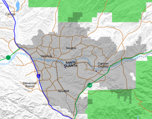
Description: Location map for the Santa Clarita Valley in southern California. The scope of the map includes the entire city of Santa Clarita, as well as the nearby unincorporated communities of Stevenson Ranch and part of Castaic. North boundary: 34.5145°N South boundary: 34.3375°N West boundary: 118.6414°W East boundary: 118.3691°W Legend: Interstate 5 California State Routes (14 and 126) Major surface streets Santa Clarita city limit Permanent bodies of water Intermittent bodies of water (Santa Clara River and tributaries) Angeles National Forest
Title: Location map Santa Clarita
Credit: Own work, with data from OpenStreetMap. Shaded relief derived from USGS.
Author: Crossover1370
Usage Terms: Creative Commons Attribution-Share Alike 4.0
License: CC BY-SA 4.0
License Link: https://creativecommons.org/licenses/by-sa/4.0
Attribution Required?: Yes
Image usage
The following 12 pages link to this image:
- Canyon Country, Santa Clarita, California
- Castaic, California
- Castaic Junction, California
- Dry Canyon Reservoir
- Mentryville, California
- Newhall, Santa Clarita, California
- Newhall Pass
- Sand Canyon, Los Angeles County, California
- Saugus, Santa Clarita, California
- Stevenson Ranch, California
- Valencia, California
- Valencia, Santa Clarita, California
