
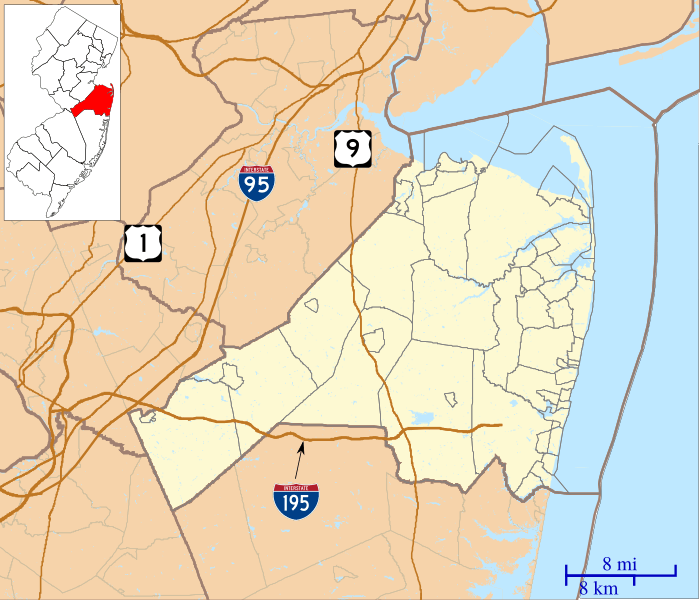
Image: Location map of Monmouth County, New Jersey

Size of this PNG preview of this SVG file: 700 × 600 pixels. Other resolution: 280 × 240 pixels.
Original image (SVG file, nominally 896 × 768 pixels, file size: 1.01 MB)
Description: This is a map of Monmouth County, New Jersey, USA which includes incorporated settlements, township borders, and major highways.
Title: Location map of Monmouth County, New Jersey
Credit: My own work, using custom-written MapScript applications with United States Census Bureau data
Author: Omnedon
Usage Terms: Public domain
License: Public domain
Attribution Required?: No
Image usage
More than 100 pages link to this image. The following list shows the first 100 page links to this image only. A full list is available.
- Adelphia, New Jersey
- Allaire, New Jersey
- Allentown, New Jersey
- Ardena, New Jersey
- Arneytown, New Jersey
- Asbury Park, New Jersey
- Bairdsville, New Jersey
- Beacon Hill, New Jersey
- Bergerville, New Jersey
- Bradevelt, New Jersey
- Branchport, New Jersey
- Burlington Heights, New Jersey
- Carrs Tavern, New Jersey
- Chapel Hill, New Jersey
- Charleston Springs, New Jersey
- Clarksburg, New Jersey
- Claytons Corner, New Jersey
- Cliffwood, New Jersey
- Cold Indian Springs, New Jersey
- Colts Neck Township, New Jersey
- Cooleys Corner, New Jersey
- Coxs Corner, Monmouth County, New Jersey
- Crawford Corners, New Jersey
- Cream Ridge, New Jersey
- Deal, New Jersey
- East Keansburg, New Jersey
- East Long Branch, New Jersey
- Elberon, New Jersey
- Ellisdale, New Jersey
- Elton, New Jersey
- Ely, New Jersey
- Emleys Hill, New Jersey
- Fair Play, New Jersey
- Fairfield, Monmouth County, New Jersey
- Fort Hancock, New Jersey
- Freehold Borough, New Jersey
- Freewood Acres, New Jersey
- Freneau, New Jersey
- Galilee, New Jersey
- Georgia, New Jersey
- Glendola, New Jersey
- Green Grove, New Jersey
- Henningers Mills, New Jersey
- Herberts Corner, Monmouth County, New Jersey
- Hillsdale, Monmouth County, New Jersey
- Hilton, New Jersey
- Hockhockson, New Jersey
- Holmeson, New Jersey
- Hornerstown, New Jersey
- Imlaystown, New Jersey
- Jerseyville, New Jersey
- Kirbys Mills, New Jersey
- Locust, New Jersey
- Long Branch, New Jersey
- Lower Squankum, New Jersey
- Manalapan Township, New Jersey
- Marlboro, Monmouth County, New Jersey
- Maxim, New Jersey
- Millhurst, New Jersey
- Monmouth Heights at Manalapan, New Jersey
- Monmouth Heights at Marlboro, New Jersey
- Montrose, New Jersey
- Morrells Corner, New Jersey
- Mount Pleasant, Monmouth County, New Jersey
- Natco, New Jersey
- Navesink Beach, New Jersey
- Nelsonville, New Jersey
- New Bedford, New Jersey
- New Canton, New Jersey
- New Monmouth, New Jersey
- Normandie, New Jersey
- North Long Branch, New Jersey
- Oakland Mills, New Jersey
- Oceanic, New Jersey
- Parkway Pines, New Jersey
- Perrineville, New Jersey
- Phalanx, New Jersey
- Pleasant Valley, Monmouth County, New Jersey
- Port-au-peck, New Jersey
- Prospertown, New Jersey
- Red Bank, New Jersey
- Robertsville, New Jersey
- Sandy Hook
- Scobeyville, New Jersey
- Sharon, New Jersey
- Shrewsbury, Upper Freehold, New Jersey
- Siloam, New Jersey
- Smithburg, New Jersey
- Smocks Corner, New Jersey
- Southard, New Jersey
- Spring Valley, New Jersey
- Squankum, New Jersey
- Stone Tavern, New Jersey
- Stonehurst East, New Jersey
- Stonehurst West, New Jersey
- Tennent, New Jersey
- Van Marters Corner, New Jersey
- Walnford, New Jersey
- Waterwitch, New Jersey
- Wayside, New Jersey

All content from Kiddle encyclopedia articles (including the article images and facts) can be freely used under Attribution-ShareAlike license, unless stated otherwise.