
Image: Location relief map United Kingdom South Lakeland

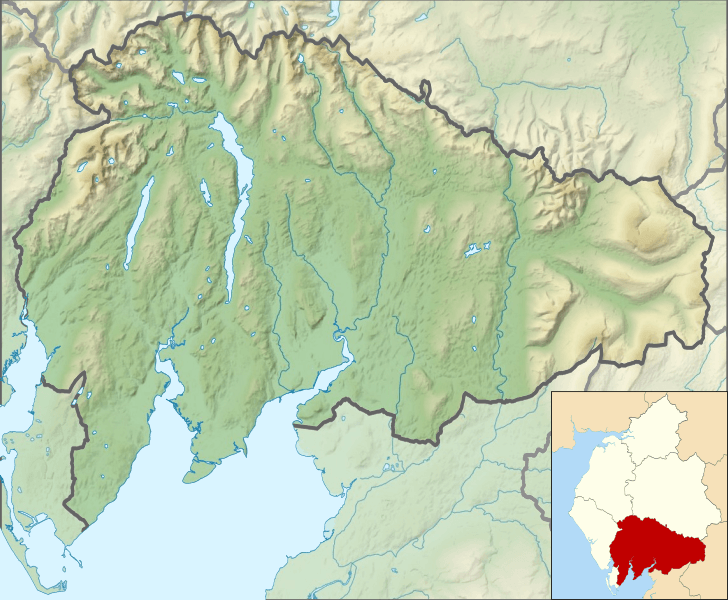
Description: Relief map of South Lakeland District, Cumbria, England in 2010. Inset highlights South Lakeland among all the districts of Cumbria. Equirectangular map projection on WGS 84 datum, with N/S stretched 170% Geographic limits: West: 3.26°W East: 2.29°W North: 54.51°N South: 54.04°N
Title: Location relief map United Kingdom South Lakeland
Credit: This file was derived from: Cumbria UK relief location map.jpg: South Lakeland UK ward map 2010 (blank).svg:
Author: Cumbria UK relief location map.jpg: Nilfanion, created using Ordnance Survey data South Lakeland UK ward map 2010 (blank).svg: Nilfanion, created using Ordnance Survey data derivative work: Dr Greg
Usage Terms: Creative Commons Attribution-Share Alike 4.0
License: CC BY-SA 4.0
License Link: https://creativecommons.org/licenses/by-sa/4.0
Attribution Required?: Yes
Image usage
The following 24 pages link to this image:
- Bigland Tarn
- Blelham Tarn
- Bowfell
- Cold Pike
- Crag Hill (Yorkshire Dales)
- Crinkle Crags
- Easedale Tarn
- Elter Water
- Esthwaite Water
- Fairfield (Lake District)
- Goat's Water
- Grasmere (lake)
- Heights Tarn
- High Street (Lake District)
- Kelly Hall Tarn
- Levers Water
- Loughrigg Tarn
- Pike of Blisco
- Rossett Pike
- Rydal Water
- Stickle Tarn, Langdale
- Tarn Hows
- Windermere
- Yew Tree Tarn
