
Image: London as fortified (1738)

Size of this preview: 800 × 497 pixels. Other resolutions: 320 × 199 pixels | 6,453 × 4,010 pixels.
Original image (6,453 × 4,010 pixels, file size: 49.43 MB, MIME type: image/png)
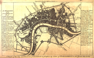
Description: An explanation and map of the fortifications of London during the English Civil War. An earth rampart surrounded the city, with 23 forts or outworks. This is a retrospective map executed in 1728 and published in 1775.
Title: London as fortified (1738)
Credit: Walter Harrison, History, Description and Survey of the Cities of London and Westminster
Author: Unknown authorUnknown author
Usage Terms: Public domain
License: Public domain
Attribution Required?: No
Image usage
The following page links to this image:

All content from Kiddle encyclopedia articles (including the article images and facts) can be freely used under Attribution-ShareAlike license, unless stated otherwise.
.png)