
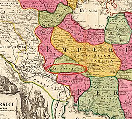
Image: Luristan in 1720

Description: Luristan in 1720
Title: Luristan in 1720
Credit: Copper engraving, hand colored in outline and wash. This decorative map shows us the empire of Persia. The map has many place names, rivers, etc. engraved. In the upper right corner we see the mileage scale with descriptive Latin text for the reader. In the lower left corner we see an allegoric figurative title cartouche with Persian inhabitants. The map extends in the north west from the Black Sea, Georgia, Armenia over the Caspian Sea towards the Persian Gulf and the Arabian Sea in the south east. This edition is without the engraved 'Privileg' in the title cartouche and was published about 1720.
Author: Homann, Johann Baptist
Usage Terms: Public domain
License: Public domain
Attribution Required?: No
Image usage
The following page links to this image:
