
Image: MH370 SIO search
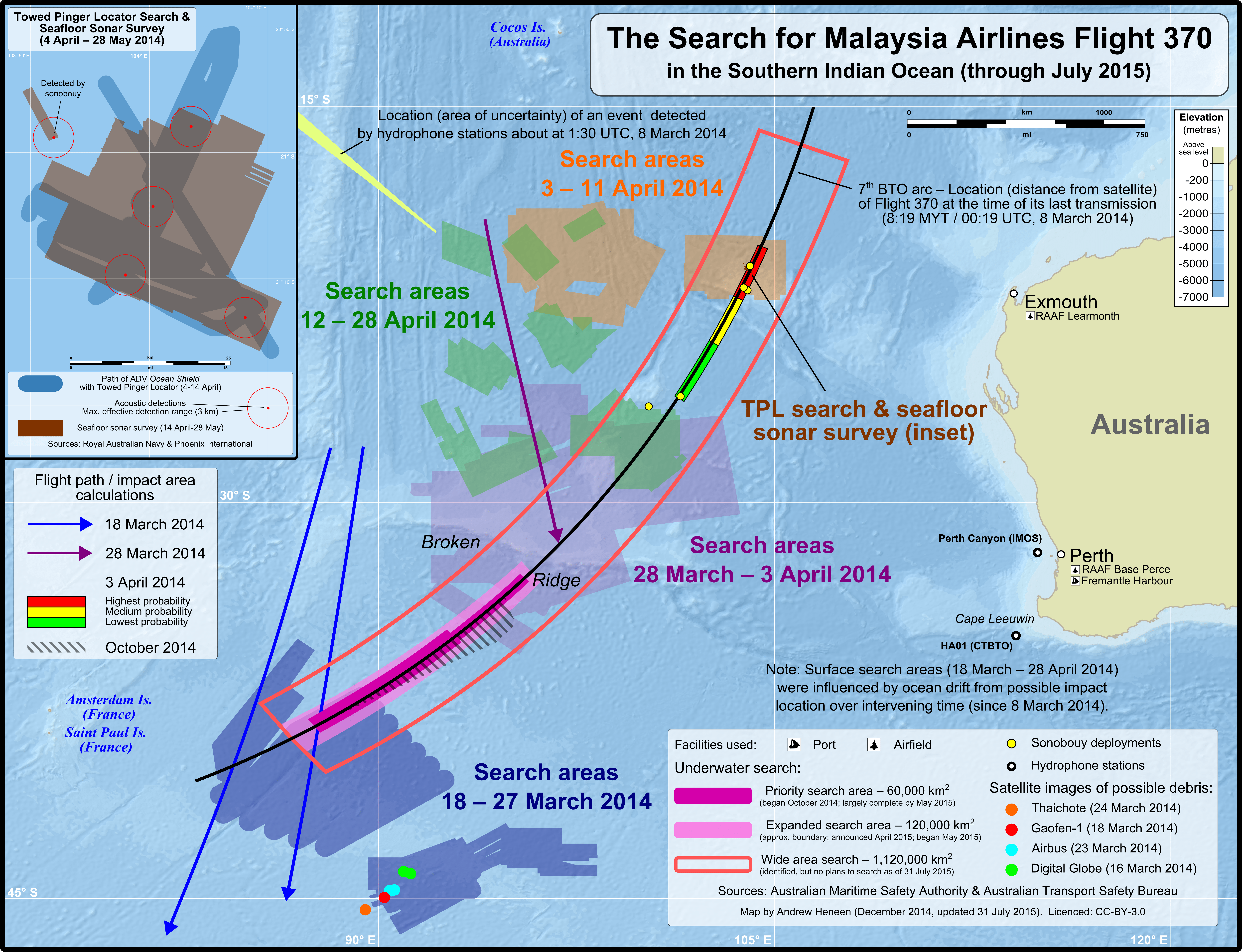
Description: Map of the search areas for Malaysia Airlines Flight 370 in the Southern Indian Ocean. Note that the search areas were determined based on several factors, including drift between the date Flight 370 disappeared (8 March 2014) and the date of the search. Not shown: A Japanese satellite spotted 10 objects possibly related to Flight 370. No coordinates for these objects could be found online; therefore, they haven't been included in the map. The bathymetric survey, which was suspended on 17 December 2014. The map released by the JACC showing the areas surveyed is in a different projection and can't easily be included in this map, but is available here: File:MH370 bathymetric survey progress 23-Dec-2014.jpg
Title: MH370 SIO search
Credit: Own work The following sources were used for data included in the map. Locations (eg. where the search was conducted, locations of satellite debris & acoustic detections) are factual information which is not subject to copyright. Most sources are noted in the map. Main map Search locations, sonobouy deployments, & calculated flight paths: Australia Maritime Safety Authority ("Cumulative area searched (handout)" maps from the MH370 Search - Media kit; 18 March-11 April) Joint Agency Coordination Centre (Media Releases—2014; Maps found at the bottom of "Search continues for Malaysian flight MH370" media releases) Possible debris satellite images (coordinates): Thaichote: BBC Gaofen-1: BBC Airbus:BBC Digital Globe: ATSB (1 & 2) 3 April probable impact areas: Australian Transport Safety Bureau – MH370 – Definition of Underwater Search Areas - Figure 5: Red, yellow and green boxes within S4-S5 and M641 route (pg. 7; source: Joint Investigation Team) October probable impact area: Australian Transport Safety Bureau – MH370 – Flight Path Analysis Update - Figures 3 & 5 (pgs. 10 & 12; source: Flight path reconstruction group) Underwater search MH370 Underwater Search Areas Planning Map (Geoscience Australia - Map number: 2014/117; 3 October 2014) Expanded underwater search based on Search for Malaysia Airlines Flight 370: Progress of Underwater Search (Geoscience Australia, 13 April 2015) Hydrophone stations and location of event detected: Australian Transport Safety Bureau – MH370 – Definition of Underwater Search Areas - Figure 35 (pg. 40; source: Curtin University) Towed Pinger Locator path & seafloor sonar survey location: Australian Transport Safety Bureau – MH370 – Definition of Underwater Search Areas Figure 12: Ocean Shield TPL search coverage 04-14 April (pg. 13; source: Phoenix International) Figure 14: Ocean Shield AUV coverage 14 April-28 May 2014 (pg. 15; source: Royal Australian Navy) Background: Bathymetric color relief derived from the ETOPO1 bedrock DEM from NOAA (public domain) Australia & island outlines: Natural Earth 1:10m Physical Vectors (public domain)
Author: Andrew Heneen
Permission: The copyright holder of this file, Andrew Heneen, allows anyone to use it for any purpose, provided that the copyright holder is properly attributed. Redistribution, derivative work, commercial use, and all other use is permitted. Attribution: Andrew Heneen Attribution I, the copyright holder of this work, hereby publish it under the following license: This file is licensed under the Creative Commons Attribution 3.0 Unported license. You are free: to share – to copy, distribute and transmit the work to remix – to adapt the work Under the following conditions: attribution – You must attribute the work in the manner specified by the author or licensor (but not in any way that suggests that they endorse you or your use of the work). http://creativecommons.org/licenses/by/3.0 CC BY 3.0 Creative Commons Attribution 3.0 truetrue
Usage Terms: Creative Commons Attribution 3.0
License: CC BY 3.0
License Link: http://creativecommons.org/licenses/by/3.0
Attribution Required?: Yes
Image usage
The following 2 pages link to this image:
