
Image: Madinat al-Zahra overall plan

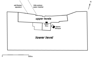
Description: Overall simplified plan of the city of Madinat al-Zahra, with a few landmarks and overall division noted. This is based on the plan published on page 7 of: Triano, Antonio Vallejo (2007), "Madinat Al-Zahra; Transformation of a Caliphal City", in Revisiting al-Andalus: perspectives on the material culture of Islamic Iberia and beyond, Editors: Glaire D. Anderson, Mariam Rosser-Owen, Brill, pp. 3-27. (Google preview here) The same map is also re-published in Bloom, Jonathan (2020), "Architecture of the Islamic West: North Africa and the Iberian Peninsula, 700-1800" on page 52 (Google preview here). This map replicates from that plan the outline of the city's outer walls, the aqueducts, and the outer perimeter of the the two upper levels where the palaces are, which includes the two large gardens to the south. The approximate shape and location of the Salon Rico and the mosque have been added for reference, but all the other details on the plan (and on other plans like it) have been left out for practical reasons and in order to focus on big-picture elements.
Title: Madinat al-Zahra overall plan
Credit: Own work
Author: R Prazeres
Usage Terms: Creative Commons Attribution-Share Alike 4.0
License: CC BY-SA 4.0
License Link: https://creativecommons.org/licenses/by-sa/4.0
Attribution Required?: Yes
Image usage
The following page links to this image:
