
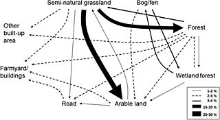
Image: Main land-cover trajectories from the 1960s to 2015

Size of this preview: 800 × 437 pixels. Other resolutions: 320 × 175 pixels | 1,200 × 656 pixels.
Original image (1,200 × 656 pixels, file size: 106 KB, MIME type: image/jpeg)
Description: The line style and relative thickness of the lines indicates the percentage of total area changed. Changes less than 1% and land-cover classes with all changes less than 1% (i.e. semi-natural wetlands and water) are not included.
Title: Main land-cover trajectories from the 1960s to 2015
Credit: https://www.tandfonline.com/doi/full/10.1080/1747423X.2018.1539779#
Author: Sigrun Aune
Usage Terms: Creative Commons Attribution-Share Alike 4.0
License: CC BY-SA 4.0
License Link: https://creativecommons.org/licenses/by-sa/4.0
Attribution Required?: Yes
Image usage
The following page links to this image:

All content from Kiddle encyclopedia articles (including the article images and facts) can be freely used under Attribution-ShareAlike license, unless stated otherwise.