
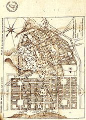
Image: Map Patras Stamatis Voulgaris 1829

Size of this preview: 428 × 600 pixels. Other resolutions: 171 × 240 pixels | 613 × 859 pixels.
Original image (613 × 859 pixels, file size: 936 KB, MIME type: image/jpeg)
Description: The first urban plan of the city of Patras, drawn up in 1829 by Stamatis Voulgaris and Auguste-Théodore Garnot, Captains in the Morea expedition.
Title: Map Patras Stamatis Voulgaris 1829
Credit: Stamatis Voulgaris, Souvenirs de Stamati Bulgari, Chef de bataillon au Corps Royal d'État-major, en retraite, A. Pihan de La Forest, Paris, 1835.
Author: Stamatis Voulgaris
Usage Terms: Public domain
License: Public domain
Attribution Required?: No
Image usage
The following 2 pages link to this image:

All content from Kiddle encyclopedia articles (including the article images and facts) can be freely used under Attribution-ShareAlike license, unless stated otherwise.