
Image: Map ancient athens

Size of this preview: 800 × 600 pixels. Other resolutions: 320 × 240 pixels | 1,000 × 750 pixels.
Original image (1,000 × 750 pixels, file size: 39 KB, MIME type: image/png)
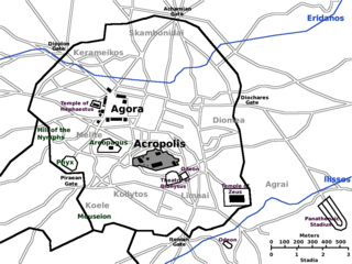
Description: Map of Ancient Athens c. 430 BC. (Athen, Athenes, Atene, Atenas). Based on the Image:Karte Athen MKL1888.png from the 1888 edition of Meyers Konversationslexikon. Revised with modern updates, but not showing the Roman-era features.
Title: Map ancient athens
Credit: Own work
Author: Singinglemon
Permission: Public domain
Usage Terms: Public domain
License: Public domain
Attribution Required?: No
Image usage
The following page links to this image:

All content from Kiddle encyclopedia articles (including the article images and facts) can be freely used under Attribution-ShareAlike license, unless stated otherwise.