
Image: Map of Battle of Cape St. George

Size of this preview: 495 × 599 pixels. Other resolutions: 198 × 240 pixels | 4,556 × 5,512 pixels.
Original image (4,556 × 5,512 pixels, file size: 3.23 MB, MIME type: image/jpeg)
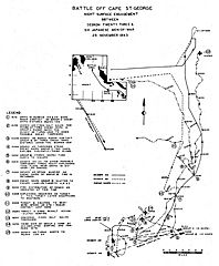
Description: Map of Battle of Cape St. George, November 25, 1943, taken from Solomon Islands Campaign: Volume XIII Bougainville Operations and the Battle of Cape St. George 3–25 November 1943, written by Office of Naval Intelligence, U.S. Navy; published by Naval History and Heritage Command.
Title: Map of Battle of Cape St. George
Credit: Solomon Islands Campaign (XIII): Bougainville Operations and the Battle of Cape St. George, 3–25 November 1943, p. 51
Author: Office of Naval Intelligence, U.S. Navy
Usage Terms: Public domain
License: Public domain
Attribution Required?: No
Image usage
The following page links to this image:

All content from Kiddle encyclopedia articles (including the article images and facts) can be freely used under Attribution-ShareAlike license, unless stated otherwise.