
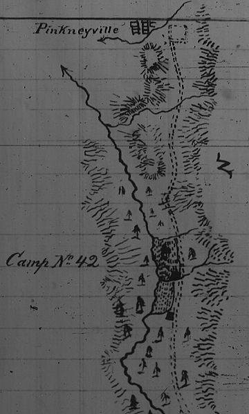
Image: Map of Fort Colville, Pinkney City, and Ft Walla Walla Fort Colville Military Road 1860

Size of this preview: 360 × 599 pixels. Other resolutions: 144 × 240 pixels | 481 × 800 pixels.
Original image (481 × 800 pixels, file size: 202 KB, MIME type: image/jpeg)
Description: Journal of the march of a detachment of U. S. recruits en route for Oregon from Coeur d'Alene to Colville Depot commanded by 1st Lt August V. Kautz, 4th Inf, Colville Valley, September 28, 1860. This is a partial map of the route of march along the Fort Walla Walla Fort Colville Military Road by Kautz and 150 recruits. Map shows the last five miles of the route.
Title: Map of Fort Colville, Pinkney City, and Ft Walla Walla Fort Colville Military Road 1860
Credit: U. S. Army Journal held in microform by University of Montana
Author: Kautz, August V., 1st Lt. U. S. Army
Usage Terms: Public domain
License: Public domain
Attribution Required?: No
Image usage
The following page links to this image:

All content from Kiddle encyclopedia articles (including the article images and facts) can be freely used under Attribution-ShareAlike license, unless stated otherwise.