
Image: Map of Insurgent Groups in the Ethiopian Civil War

Size of this PNG preview of this SVG file: 593 × 599 pixels. Other resolution: 238 × 240 pixels.
Original image (SVG file, nominally 1,843 × 1,862 pixels, file size: 692 KB)
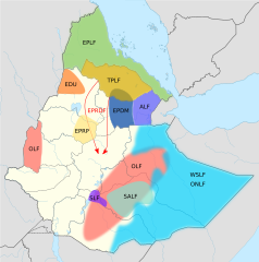
Description: A map of the approximate areas of operation of insurgent groups in the Ethiopian Civil War. This is not necessarily the area controlled by the group, just the primary area in which it operated. WSLF and ONLF had approximately the same area of operation. The more conventional EPRDF drive on Addis Ababa from 1989-1991 is indicated by two red arrows
Title: Map of Insurgent Groups in the Ethiopian Civil War
Credit: Own work
Author: Leviavery Base map: File:Ethiopia (1941-1987) location map.svg
Usage Terms: Creative Commons Attribution-Share Alike 4.0
License: CC BY-SA 4.0
License Link: https://creativecommons.org/licenses/by-sa/4.0
Attribution Required?: Yes
Image usage
The following page links to this image:

All content from Kiddle encyclopedia articles (including the article images and facts) can be freely used under Attribution-ShareAlike license, unless stated otherwise.