
Image: Map of Unter den Linden, Berlin

Size of this preview: 800 × 526 pixels. Other resolutions: 320 × 210 pixels | 878 × 577 pixels.
Original image (878 × 577 pixels, file size: 28 KB, MIME type: image/gif)
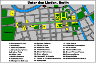
Description: Map of Unter den Linden, Berlin, with important places and buldings along or around the street. The map was made in 2006.
Title: Map of Unter den Linden, Berlin
Credit: http://en.wikipedia.org/wiki/File:Map_of_Unter_den_Linden,_Berlin.gif
Author: Adam Carr
Usage Terms: Creative Commons Attribution-Share Alike 3.0
License: CC BY-SA 3.0
License Link: http://creativecommons.org/licenses/by-sa/3.0
Attribution Required?: Yes
Image usage
The following page links to this image:

All content from Kiddle encyclopedia articles (including the article images and facts) can be freely used under Attribution-ShareAlike license, unless stated otherwise.