
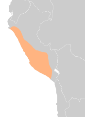
Image: Map of Wari in Peru

Size of this PNG preview of this SVG file: 267 × 365 pixels. Other resolution: 175 × 240 pixels.
Original image (SVG file, nominally 267 × 365 pixels, file size: 154 KB)
Description: The aproximate expansion of the Wari Empire ca. 800 AD
Title: Map of Wari in Peru
Credit: Own work
Author: qQuantum
Usage Terms: Creative Commons Attribution-Share Alike 4.0
License: CC BY-SA 4.0
License Link: https://creativecommons.org/licenses/by-sa/4.0
Attribution Required?: Yes
Image usage
The following 3 pages link to this image:

All content from Kiddle encyclopedia articles (including the article images and facts) can be freely used under Attribution-ShareAlike license, unless stated otherwise.