
Image: Map of Williamsburg Virginia 1702 Franz Michel
No higher resolution available.
Map_of_Williamsburg_Virginia_1702_Franz_Michel.jpg (432 × 272 pixels, file size: 46 KB, MIME type: image/jpeg)
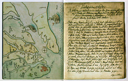
Description: One of the earliest maps of Williamsburg (Middle Plantation), drawn by Franz Michel, a native of Switzerland who traveled to America. Michel's fanciful map shows ships, deer and a turkey, as well as Williamsburg "between the Jems and Jorgk Rivier, six miles from the Jems and ten from Jorgtown." On the page facing the map is a letter from Michel to his brother Hans.
Title: Map of Williamsburg Virginia 1702 Franz Michel
Credit: http://www.patc.us/history/native/michel2.html
Author: Franz Michel
Usage Terms: Public domain
License: Public domain
Attribution Required?: No
Image usage
The following page links to this image:

All content from Kiddle encyclopedia articles (including the article images and facts) can be freely used under Attribution-ShareAlike license, unless stated otherwise.