
Image: Map of Worcestershire in 1642
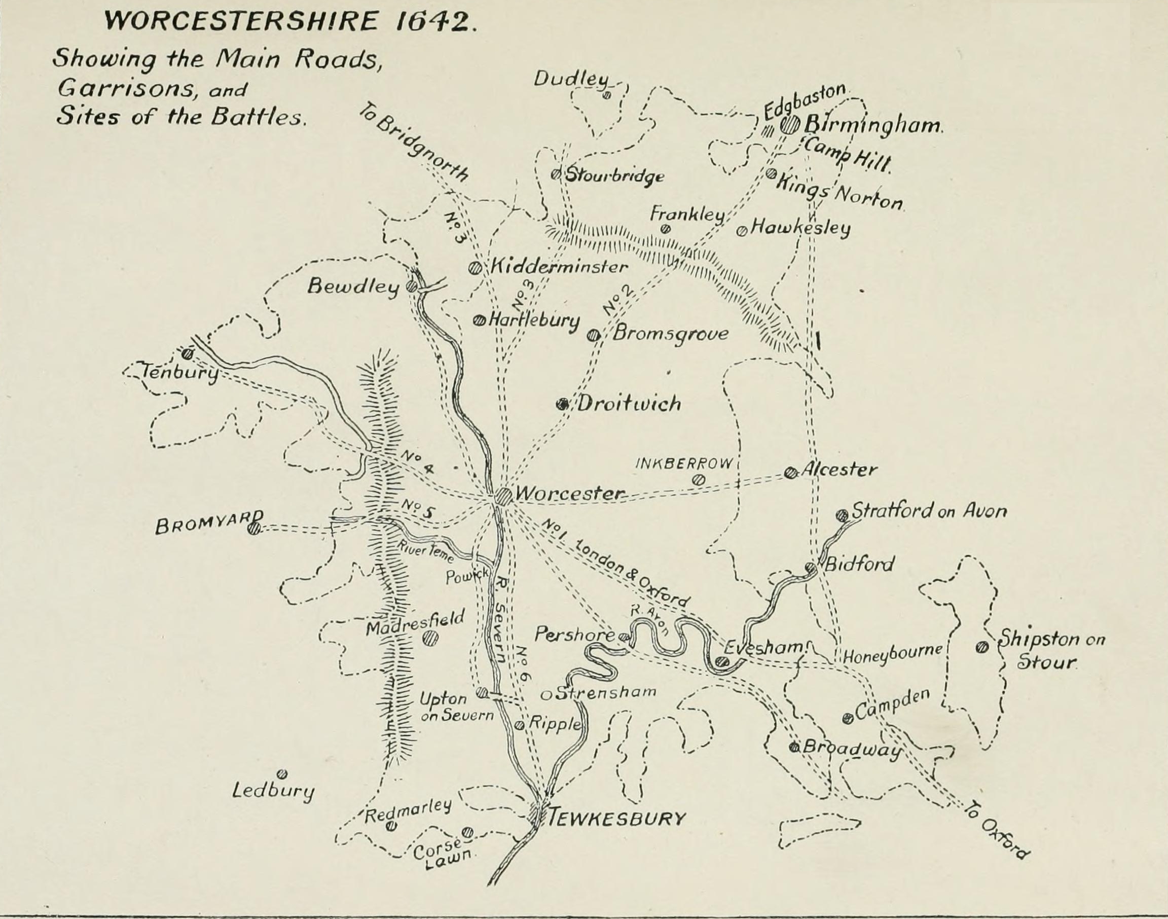
Description: Map of the main roads, garrisons and battle of the English Civil War in Worcestershire. The six roads numbered on the map are the important thoroughfares that linked Worcester with the rest of the country: (1.) The Oxford and London Road. This entered the County near Honeybourne, passed through Bretforton, over the Avon at Offenham at Twyford Bridge, where Offenham Boat is now, then through Norton, Wyre, Pinvin, White Ladies' Aston, Spetchley, Red Hill, to Worcester. This is and was the direct road from Worcester to Oxford, and by it all convoys of supplies and all detachments of recruits would have to pass. (2.) At Worcester this road divided, one branch to the right is the road to the north, spoken of, near Birmingham, as the " Bristol Road." It crossed Barbourne Bridge and went to Droitwich, Bromsgrove, over the Lickey to Northfield, and passed out of the County into Warwickshire at Bourn Brook. (3.) Another branch, also going to the north, after crossing Barbourne Bridge, went to the left through Ombersley and Hartlebury; here it again branches off the road to the right, going through the parishes of Chaddesley Corbett and Belbroughton, past Hagley and Pedmore to Stourbridge into Staffordshire. This is the road by which Charles II went after the Battle of Worcester. The road to the right at Hartlebury passed through Kidderminster, and so on to Bridgnorth. (4.) The road crossing the Severn at Worcester, and going by Kenswick, Martley, crossing the Teme at Ham Bridge, through Clifton-on-Teme to Tenbury, and then into Shropshire. On this road is the Tenbury Bridge over the Teme. When this was damaged in 1615, the town of Tenbury asked the Sessions to help to repair it, as it was "the great thoroughfare from most places in Wales to the City of London." (5.) The road from Worcester crossing the Severn, proceeding by Cotheridge, Broadwas, across the Teme at Knightsford Bridge, and so on to Bromyard, thence to Hereford and Wales. Along this road the troops sent with Lord Stamford to occupy Hereford in 1642 returned, and Charles I marched along it to relieve Hereford in 1645. (6.) The road from Worcester going south along the east bank of the river (the Bath) road, passing through Kempsey, Severn Stoke, to Tewkesbury and Gloucester. It was along this road Waller advanced to attack Worcester in 1643. There were other important roads, but they were more of local importance, or else served as alternative routes.
Title: Map of Worcestershire in 1642
Credit: The Civil War In Worcestershire, 1642-1646: And the Scotch Invasion Of 1651, Birmingham: The Midland Educational Company, p. 8
Author: John William Willis-Bund
Usage Terms: Public domain
License: Public domain
Attribution Required?: No
Image usage
The following page links to this image:
