
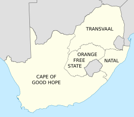
Image: Map of the provinces of South Africa 1910-1976 with English labels

Size of this PNG preview of this SVG file: 684 × 599 pixels. Other resolution: 274 × 240 pixels.
Original image (SVG file, nominally 809 × 709 pixels, file size: 393 KB)
Description: Map of South Africa showing the provinces as they were from 1910 to 1976, with labels in English. Based on File:Map of South Africa with provincial borders 1910-1976.svg.
Title: Map of the provinces of South Africa 1910-1976 with English labels
Credit: Own work
Author: Htonl
Usage Terms: Creative Commons Attribution-Share Alike 3.0
License: CC BY-SA 3.0
License Link: https://creativecommons.org/licenses/by-sa/3.0
Attribution Required?: Yes
Image usage
The following page links to this image:

All content from Kiddle encyclopedia articles (including the article images and facts) can be freely used under Attribution-ShareAlike license, unless stated otherwise.