
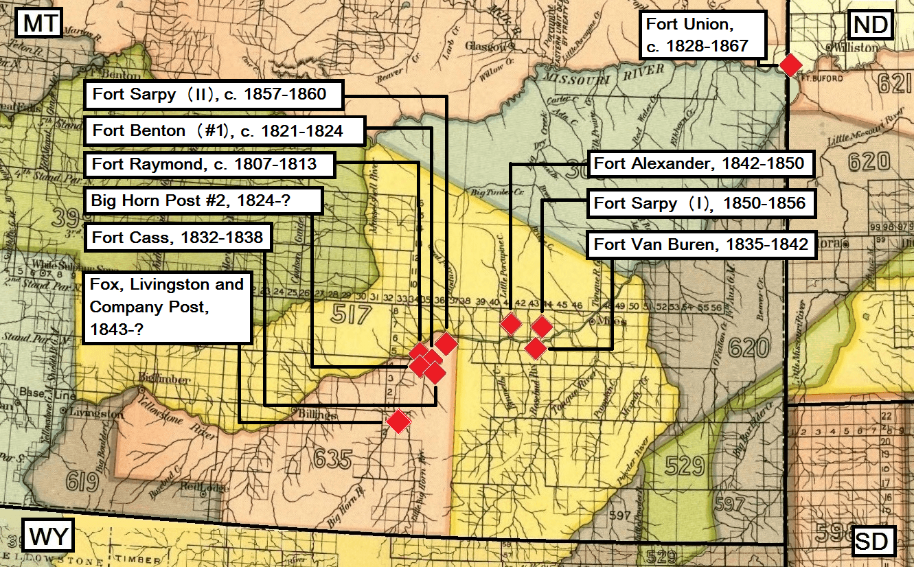
Image: Map with trading posts built for trade with the Crows, 1807-1867
Description: Map adapted to text about the Crows and the fur trade in Montana. Big Horn Post #2 was built near the mouth of Bighorn River. (Montana Historic Preservation Plan (1975). Volume II. Helena. P. 127.) Fort Alexander six miles west of Forsyth. (Montana Historic Preservation Plan, p. 114.) Fort Benton (#1) near the mouth of Bighorn River in 1821. (Montana Historic Preservation Plan, p. 127.) Hoxie says the fort was erected in 1822. (Hoxie, Frederick E. (1995): Parading Through History. The Making of the Crow Nation in America, 1805-1935. Cambridge. P. 67.) This trading post is not to be confused with Fort Benton built for trade with the Blackfeet in 1846. (Montana Historic Preservation Plan, p. 35.) Fort Cass was built two miles from the mouth of the Bighorn. (Montana Historic Preservation Plan, p. 127.) Also called Fort Tulloch, Tulloch’s Fort or variations of this name. Fort Raymond was built at the mouth of the Bighorn. (Montana Historic Preservation Plan, p. 127.) Also known as Fort Manuel Lisa, Fort Lisa and Big Horn Post #1. Heidenreich says the fort was closed down in 1811. (Heidenreich, Charles A. (1971): Ethno-Documentary of the Crow Indians of Montana, 1824-1862. University of Oregon, Ph.D., 1971. Anthropology. P. 50.) Fort Sarpy (I) was built ten miles east of Forsyth. (Montana Historic Preservation Plan, p. 114.) Operations continued to 1856. (McDonnell, Anne (Ed.): The Fort Sarpy Journal, 1855-1856. Contributions to the Historical Society of Montana. Volume Ten. 1940.) Fort Sarpy (II). (Hoxie, p. 68.) Heidenreich says the fort was closed down about 1859. (Heidenreich, p. 72.) Fort Union. According to Hoxie the fort was built in 1829 (p. 69). Fox states the fort was active to 1867. (Fox, Gregory L. (1988): A Late Nineteenth Century Village of a Band of Dissident Hidatsa: The Garden Coulee Site (32WI18). Lincoln. P. 15.) Others again say the post carried out trade from 1828-1860. (Montana Historic Preservation Plan, p. 111.) Fort Van Buren stood ten miles east of Forsyth according to the Montana Historic Preservation Plan, p. 114. The sources disagree which tributary the post was close to, so Heidenreich gives the Rosebud (as shown on the map), while some have the post close to the mouth of Tongue River. (Heidenreich, p. 72. Chardon, F. A. (1997): Chardon’s Journal at Fort Clark, 1834-1839. Lincoln and London. P. 315. Chittenden, Hiram Martin (1954): The American Fur Trade. Vol. II. Stanford. P. 965.) Hoxie says it was erected in 1839. (Hoxie, p. 68.)
Title: Map with trading posts built for trade with the Crows, 1807-1867
Credit: 18th annual Report of the Bureau of American Ethnology, 1896-'97. Part II. Smithsonian Institution. Washington, 1899, GPO
Author: Unknown author
Usage Terms: Public domain
License: Public domain
Attribution Required?: No
Image usage
The following 2 pages link to this image:
