
Image: Mapa del Territorio Muisca

Size of this PNG preview of this SVG file: 591 × 599 pixels. Other resolution: 237 × 240 pixels.
Original image (SVG file, nominally 774 × 785 pixels, file size: 269 KB)
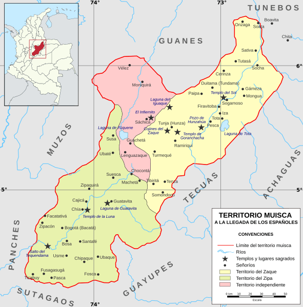
Description: Mapa del territorio Muisca a la llegada de los españoles (siglo XV)
Title: Mapa del Territorio Muisca
Credit: Own work Territorio Muisca Historia Crítica: transición entre el ordenamiento territorial prehispánico y colonial en la Nueva Granada Pueblos originarios: Muiscas Etnografía muisca
Author: Milenioscuro
Usage Terms: Creative Commons Attribution-Share Alike 3.0
License: CC BY-SA 3.0
License Link: https://creativecommons.org/licenses/by-sa/3.0
Attribution Required?: Yes
Image usage
The following 16 pages link to this image:
- Altiplano Cundiboyacense
- Bacatá
- Battle of Chocontá
- Battle of Pasca
- Battle of Tocarema
- Cabildo Mayor del Pueblo Muisca
- Checua
- Diego de Torres y Moyachoque
- Herrera Period
- Muisca
- Muisca art
- Muisca economy
- Spanish conquest of the Chibchan nations
- Spanish conquest of the Muisca
- Tibitó
- Template:Timeline of inhabitation of the Altiplano Cundiboyacense

All content from Kiddle encyclopedia articles (including the article images and facts) can be freely used under Attribution-ShareAlike license, unless stated otherwise.