
Image: Marietta Battlefields Georgia

Size of this preview: 769 × 599 pixels. Other resolutions: 308 × 240 pixels | 1,860 × 1,450 pixels.
Original image (1,860 × 1,450 pixels, file size: 1.34 MB, MIME type: image/jpeg)
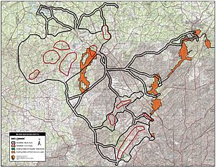
Description: Map of battlefield core and study areas. The Marietta Operations include the engagements at Brushy Mountain, Gilgal Church, Johnston River Line, Lost Mountain, Mud Creek Line, Noonday Creek, Pine Knob, Pine Mountain, Ruff's Mill, Smyrna, and Vining.
Title: Marietta Battlefields Georgia
Credit: National Park Service
Author: American Battlefield Protection Program
Usage Terms: Public domain
License: Public domain
Attribution Required?: No
Image usage
The following page links to this image:

All content from Kiddle encyclopedia articles (including the article images and facts) can be freely used under Attribution-ShareAlike license, unless stated otherwise.