
Image: Maritime-prefectures

Size of this preview: 800 × 450 pixels. Other resolutions: 320 × 180 pixels | 5,312 × 2,988 pixels.
Original image (5,312 × 2,988 pixels, file size: 3.78 MB, MIME type: image/jpeg)
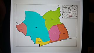
Description: Map of Prefectures of the Maritime region of Togo. Created by Rarelibra on December 27th 2006 for public domain use. No machine-readable source provided. Rarelibra's own work assumed (based on copyright claims). The copyright holder of this work, release this work into the Public domain. He grants anyone the right to use this work for any purpose.
Title: Maritime-prefectures
Credit: No machine-readable source provided. Created by Rarelibra (based on copyright claims).
Author: Rarelibra
Usage Terms: Creative Commons Zero, Public Domain Dedication
License: CC0
License Link: http://creativecommons.org/publicdomain/zero/1.0/deed.en
Attribution Required?: No
Image usage
The following 2 pages link to this image:

All content from Kiddle encyclopedia articles (including the article images and facts) can be freely used under Attribution-ShareAlike license, unless stated otherwise.