
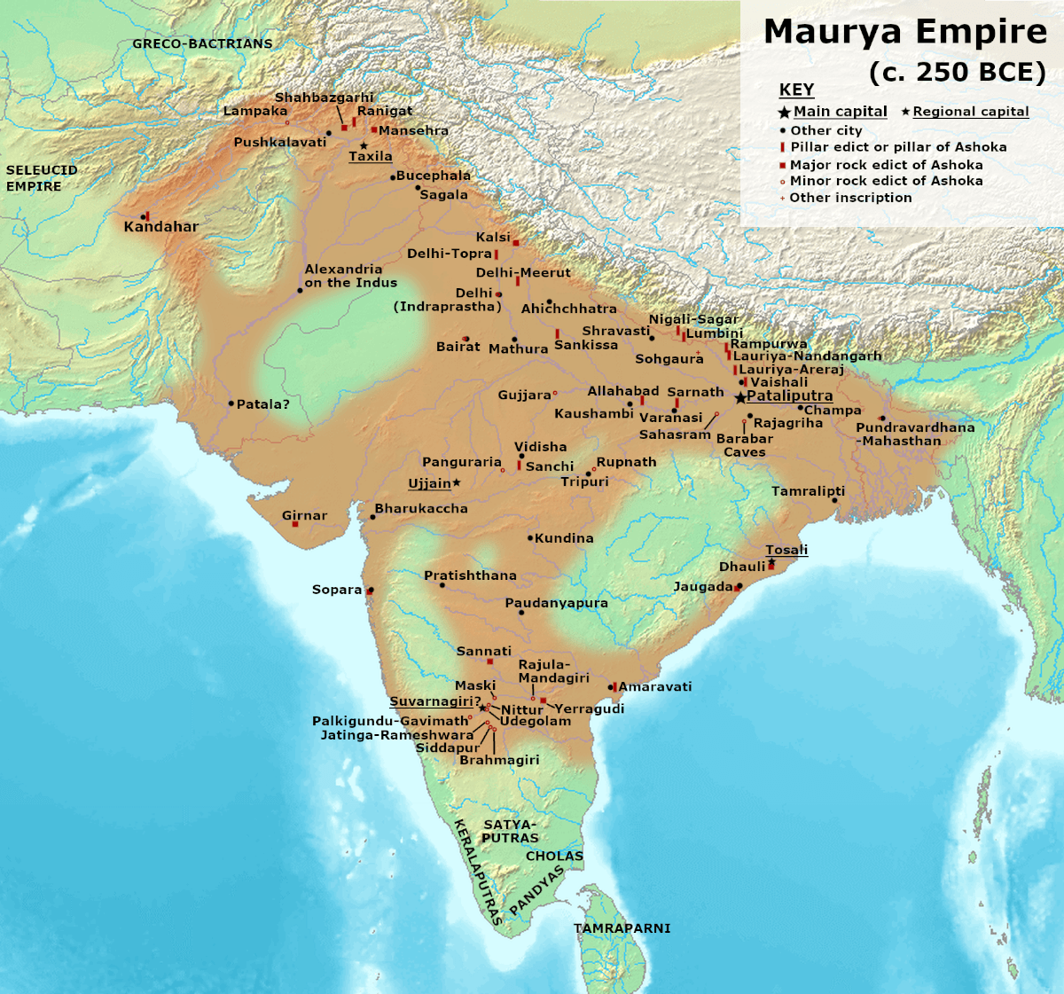
Image: Maurya Empire, c.250 BCE
Description: This is based on the map provided on p. 69 of Kulke, H.; Rothermund, D. (2004), A History of India, 4th, Routledge, ISBN 978-0-415-32920-0. According to the authors, the empty areas within the boundaries of the empire were the "autonomous and free tribes". For individual edicts, see also: Schwartzberg, J. E. (1992), A Historical Atlas of South Asia: University of Oxford Press; and https://en.wikipedia.org/wiki/List_of_Edicts_of_Ashoka According to both Kulke & Rothermund (p. 68-71), as well as Stein (p. 74), large areas, especially in the Deccan peninsula, were probably occupied by fairly autonomous or even unconquered tribes. "The major part of the Deccan was ruled by [Mauryan administration]. But in the belt of land on either side of the Nerbudda, the Godavari and the upper Mahanadi there were, in all probability, certain areas that were technically outside the limits of the empire proper. Asoka evidently draws a distinction between the forests and the inhabiting tribes which are in the dominions (vijita) and peoples on the border (anta avijita) for whose benefit some of the special edicts were issued. Certain vassal tribes are specifically mentioned." (Raychaudhuri & Mukherjee pp. 275-6) See also --Stein, Burton (1998). A History of India (1st ed.), Oxford: Wiley-Blackwell. --Raychaudhuri, H. C.; Mukherjee, B. N. (1996). Political History of Ancient India: From the Accession of Parikshit to the Extinction of the Gupta Dynasty. Oxford University Press. Background from http://www2.demis.nl/mapserver/mapper.asp Made with GIMP
Title: Maurya Empire, c.250 BCE
Credit: Own work
Author: Avantiputra7
Usage Terms: Creative Commons Attribution-Share Alike 3.0
License: CC BY-SA 3.0
License Link: https://creativecommons.org/licenses/by-sa/3.0
Attribution Required?: Yes
Image usage
The following page links to this image:
