
Image: Medieval Livonia 1260

Size of this PNG preview of this SVG file: 554 × 600 pixels. Other resolution: 222 × 240 pixels.
Original image (SVG file, nominally 955 × 1,034 pixels, file size: 734 KB)
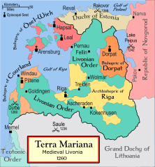
Description: A political map of the Medieval Livonia, circa 1260, along with surrounding areas. Originally created by MapMaster This map was commissioned by Attilios.
Title: Medieval Livonia 1260
Credit: No machine-readable source provided. Own work assumed (based on copyright claims).
Author: No machine-readable author provided. Termer assumed (based on copyright claims).
Usage Terms: Creative Commons Attribution-Share Alike 3.0
License: CC-BY-SA-3.0
License Link: http://creativecommons.org/licenses/by-sa/3.0/
Attribution Required?: Yes
Image usage
The following 5 pages link to this image:

All content from Kiddle encyclopedia articles (including the article images and facts) can be freely used under Attribution-ShareAlike license, unless stated otherwise.