
Image: Mississippi-Coast-towns-NOAA
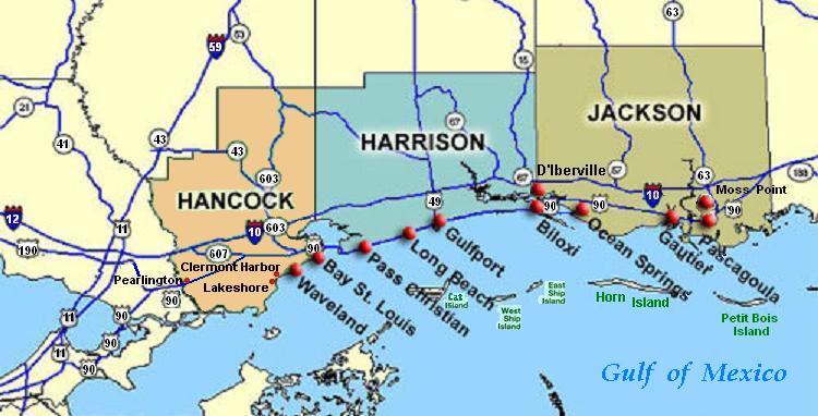
Description: Coastal map of the U.S. state of Mississippi, showing major towns and cities in the three coastal counties: Hancock, Harrison, and Jackson County. Also shown are Cat Island, West Ship Island, East Ship Island, Horn Island and Petit Bois Island.The locations of towns, roads and offshore islands are based on NOAA and NASA maps.
Title: Mississippi-Coast-towns-NOAA
Credit: Own work; self-made (hand-edited with MS-Paint) Reference maps: NOAA map of Mississippi counties: NOAA-Coop-MS. NASA map of towns/roads/islands: NASA-SSC-regional-map. The map is in quick JPEG format, for large display as highly readable, in about 20 articles that display the map. JPEG clarity is enhanced by painted areas behind many labels, causing the wording to be clearer than even a massive SVG or PNG-format file could provide, due to the sharp display contrast of JPEG files. JPEG Clarity: Even though JPEG images have artifacts, they can display clearer wording in small maps due to auto-contrast enhancement. The same painted/shaded areas, that illuminate wording, would make the map excessively gargantuan in slow cumbersome PNG or SVG format, as is the case with terrain maps, which also should NEVER be converted to massive PNG format.
Author: Wikid77
Usage Terms: Public domain
License: Public domain
Attribution Required?: No
Image usage
The following 15 pages link to this image:
- Bay St
- Bay St. Louis, Mississippi
- Biloxi, Mississippi
- Cat Island (Mississippi)
- Effects of Hurricane Katrina in Mississippi
- Gautier, Mississippi
- Gulfport, Mississippi
- Hancock County, Mississippi
- Long Beach, Mississippi
- Ocean Springs, Mississippi
- Pascagoula, Mississippi
- Pass Christian, Mississippi
- Pearlington, Mississippi
- Ship Island (Mississippi)
- Waveland, Mississippi
