
Image: Mount & Page Chart of the Bay of Mexico 1700 UTA

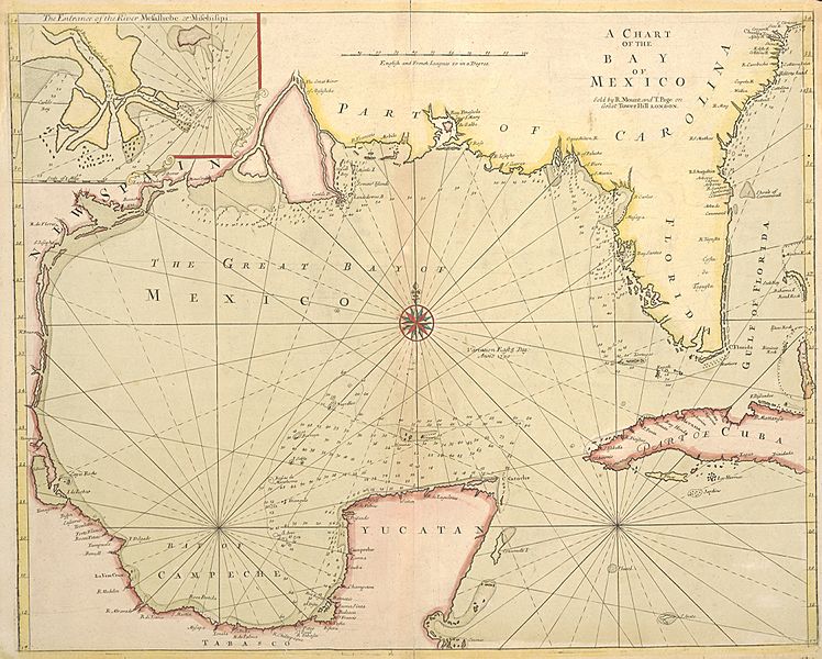
Description: Until the publication of Guillaume Delisle's famous map Carte de la Louisiane of 1718, this English sea chart was the best printed map available of the Gulf Coast and the mouth of the Mississippi. The British book, map, and chart-making and publishing firm of Mount & Page may have issued the map separately as early as 1700 since that date appears to the east of the compass rose in the center of the Gulf. Coastal mapping scholar Jack Jackson speculated that the English probably had access to a captured copy of Spanish pilots Juan Enriquez Barroto's or Juan Bisente del Campo's maps of the Gulf Coast since they reflect Bisente's coastal details and Barroto's toponyms. Jackson also believed that the inset map at upper left may be based upon information from Captain William Bond's 1699 reconnaissance voyage of the mouth of the Mississippi on behalf of Dr. Daniel Coxe's Anglo-Dutch Carolana Company. At that time Bond's ship ascended the river to a point just below New Orleans before Bienville convinced him that the French already controlled the river. Unfortunately, Bond's presumed charts are missing. Mount & Page's chart and its Gulf coast interpretation was also influential for other English chartmakers.
Title: A Chart of the Bay of Mexico
Credit: Cartographic Connections: map / text
Author: Richard Mount
Usage Terms: Public domain
License: Public domain
Attribution Required?: No
Image usage
The following page links to this image:
