
Image: Mount Rainier Hazard Map-en

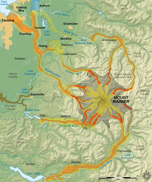
Description: English: Hazard map around the Mount Rainier, state of Washington, United States. Lava flow and pyroclastic flows Electron Mudflow-sized event (generally large in size) National Lahar-sized event (generally moderate in size) Lahars not necessarily associated to volcanism (generally small) Flooding after lahar event Potential area of inundation from failure of Alder Dam County boundary Mount Rainier National Park boundary City
Title: Mount Rainier Hazard Map-en
Credit: English: Own work. Data sources : Background map : NASA Shuttle Radar Topography Mission (SRTM3 v.2) (public domain) Hazard data : this map of the USGS (United States Geological Survey). Additional data (rivers, borders, cities) : Demis compass rose from Compass rose pale.svg (opacified) created by Fibonacci under GFDL ; scale from Image:Scale_kilometres_miles_svg.svg by Sémhur under Public Domain. Softwares used : NASA datas edited with Global Mapper 9 (limited version) by the United States Geological Survey (USGS) and 3DEM from Visualization Software LLC Additional data Vectorized with Inkscape The Gimp ; Creation Map Tutorial (in french) Others : UTM map projection WGS84 geodetic system shaded relief (composite image of N-W, W and N lightning positions).
Author: Sémhur
Usage Terms: Public domain
License: Public domain
Attribution Required?: No
Image usage
The following 3 pages link to this image:
