
Image: Mt Vesuvius 79 AD eruption

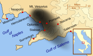
Description: A map showing the cities and towns affected by the eruption of Mount Vesuvius in 79 AD. The general shape of the ash and cinder fall (see w:en:pyroclast) is shown by the dark area to the southeast of Mt Vesuvius. (P.S. It seems strange to show the modern day English names for the two bodies of water - I am open to suggestions). This map shows lines and uses the Mercator projection (although that is not important on a map of this scale). North is, as usual, at the top of the map.
Title: Mt Vesuvius 79 AD eruption
Credit: Own work
Author: MapMaster
Usage Terms: Creative Commons Attribution-Share Alike 3.0
License: CC BY-SA 3.0
License Link: http://creativecommons.org/licenses/by-sa/3.0
Attribution Required?: Yes
Image usage
The following page links to this image:
