
Image: Myanmar Disaster Topography

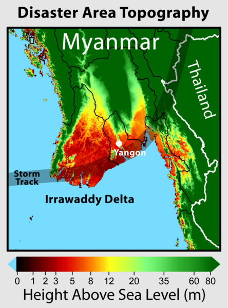
Description: This map shows the elevation of those regions of Myanmar hardest hit by Cyclone Nargis. The track of the cyclone's eye is indicated. The low lying Irrawaddy Delta was among the hardest hit regions and was affected by both flooding and storm surge. Elevation data is based on NASA SRTM. Additional elevation imagery available at GWArt
Title: Myanmar Disaster Topography
Credit: Own work
Author: Robert A. Rohde
Permission: Permission is granted to copy, distribute and/or modify this document under the terms of the GNU Free Documentation License, Version 1.2 only as published by the Free Software Foundation; with no Invariant Sections, no Front-Cover Texts, and no Back-Cover Texts. A copy of the license is included in the section entitled GNU Free Documentation License. 1.2 onlyhttp://www.gnu.org/licenses/old-licenses/fdl-1.2.htmlGFDL 1.2GNU Free Documentation License 1.2truetrue
Usage Terms: GNU Free Documentation License 1.2
License: GFDL 1.2
License Link: http://www.gnu.org/licenses/old-licenses/fdl-1.2.html
Attribution Required?: Yes
Image usage
The following page links to this image:
