
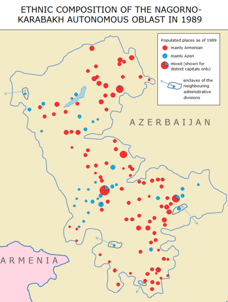
Image: Nagorno Karabakh Ethnic Map 1989

Size of this preview: 451 × 599 pixels. Other resolutions: 181 × 240 pixels | 737 × 979 pixels.
Original image (737 × 979 pixels, file size: 84 KB, MIME type: image/png)
Description: Ethnic composition of the Nagorno-Karabakh Autonomous Oblast in 1989, based on: Arthur Tsutsiev, Atlas of Ethno-Political History of the Caucasus, 1774-2004, Europa: Moscow, 2006, available at: http://www.iriston.com/books/cuciev_-_etno_atlas/thumb/t_map33.jpg
Title: Nagorno Karabakh Ethnic Map 1989
Credit: Own work
Author: Parishan
Usage Terms: Creative Commons Attribution-Share Alike 3.0
License: CC BY-SA 3.0
License Link: http://creativecommons.org/licenses/by-sa/3.0
Attribution Required?: Yes
Image usage
The following page links to this image:

All content from Kiddle encyclopedia articles (including the article images and facts) can be freely used under Attribution-ShareAlike license, unless stated otherwise.