
Image: Narita International Airport landsat
No higher resolution available.
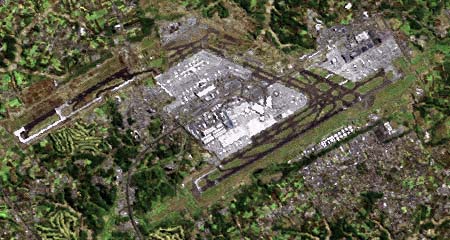
Narita_International_Airport_landsat.jpg (240 × 450 pixels, file size: 65 KB, MIME type: image/jpeg)
Description: 成田国際空港ラッドサット画像(2001年)。画像の上半分には建設中の暫定平行滑走路(2002年に供用開始)も見える。
Title: Narita International Airport landsat
Credit: The Landsat satellite pictures are used for this image. The data came from Global Land Cover Facility (GLCF), and are processed with Kashmir 3D. この画像には、ランドサット衛星画像が用いられています。これは、メリーランド大学 / Global Land Cover Facility 所蔵のデータにより、カシミール3Dにより画像化したものです。 Transferred from Japanese Wikipedia; ja:ファイル:Narita International Airport landsat.jpg
Author: Tdk at Japanese Wikipedia
Usage Terms: Creative Commons Attribution-Share Alike 3.0
License: CC-BY-SA-3.0
License Link: http://creativecommons.org/licenses/by-sa/3.0/
Attribution Required?: Yes
Image usage
There are no pages that link to this image.

All content from Kiddle encyclopedia articles (including the article images and facts) can be freely used under Attribution-ShareAlike license, unless stated otherwise.