
Image: Near east lrg

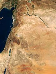
Description: This true-color image of the region was taken on September 10, 2000, by the MODerate-resolution Imaging Spectroradiometer (MODIS) flying aboard NASA's Terra spacecraft. The image shows the lands of Israel along the eastern shore of the Mediterranean Sea, with the countries of Jordan to the southeast and Syria to the Northeast. Jerusalem is Israel's capital city and Amman is the capital of Jordan. The region known as the West Bank lies between the two countries. Running from north to south, the Jordan River links the Sea of Galilee to the Dead Sea. Click the image to enlarge it, and to see the borders drawn in. Image courtesy Jacques Descloitres, MODIS Land Group, NASA GSFC
Title: Near east lrg
Credit: http://earthobservatory.nasa.gov/Newsroom/NewImages/Images/modis_near_east_lrg.jpg
Author: NASA, earthobservatory, http://earthobservatory.nasa.gov/
Permission: PD-USGov-NASA
Usage Terms: Public domain
License: Public domain
Attribution Required?: No
Image usage
The following page links to this image:
