
Image: Neo-Babylonian Empire under Nabonidus map

Size of this preview: 578 × 599 pixels. Other resolutions: 231 × 240 pixels | 2,604 × 2,700 pixels.
Original image (2,604 × 2,700 pixels, file size: 5.55 MB, MIME type: image/png)
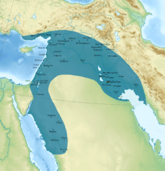
Description: Map of the Neo-Babylonian Empire at its greatest territorial extent, under its final king Nabonidus. Follows the map of the Babylonian Empires produced by National Geographic (link), with the addition of the various cities conquered by Nabonidus in his Arabian Campaign, based on information in Paul-Alain Beaulieu's Reign of Nabonidus, King of Babylon (556-539 BC) (1989), p. 173
Title: Neo-Babylonian Empire under Nabonidus map
Credit: Own work
Author: Ichthyovenator
Usage Terms: Creative Commons Attribution-Share Alike 4.0
License: CC BY-SA 4.0
License Link: https://creativecommons.org/licenses/by-sa/4.0
Attribution Required?: Yes
Image usage
The following 4 pages link to this image:

All content from Kiddle encyclopedia articles (including the article images and facts) can be freely used under Attribution-ShareAlike license, unless stated otherwise.