
Image: Neuquén Basin
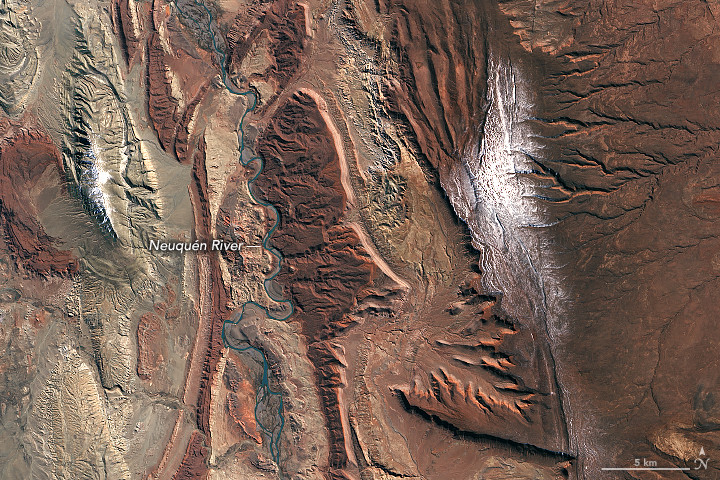
Description: As the Neuquén River winds its way from the Andes through west-central Argentina toward the Atlantic Ocean, it passes a spectacular series of rock formations in the Neuquén Basin. For paleontologists, the basin is a great place to find fossils, particularly dinosaurs. And for those in the oil business, it is fertile ground for gas and oil exploration. The Operational Land Imager (OLI) on Landsat 8 acquired an image showing part of the basin on September 3, 2018. From space, boundaries between some of the major groups of sedimentary rock formations are visible. In the first image, the deep reds of the Candeleros Formation—a sequence of sandstones formed roughly 90 to 100 million years ago in a braided river system—dominate the landscape. These rocks are flanked in some areas, especially near the river, by a green-yellow sequence of rocks that are part of the younger Hunical Formation, formed during drier times. The older Royosa Formation, meanwhile, peeks through in some areas where erosion has scraped away overlying rock layers. (See the second image at link above.) Paleontologists have uncovered quite a menagerie of fossilized fauna in Candeleros rocks, including ancient species of fish, frogs, snakes, turtles, small mammals, and several types of dinosaurs. Few of the fossilized creatures have received the notoriety of Giganotosaurus carolinii—a carnivorous theropod thought to be larger and faster than Tyrannosaurs Rex. Petroleum geologists are more interested in what lies beneath the Candeleros Formation. Several layers of rock, formed when the area was covered by an ocean, contain gas and oil. While drilling has been ongoing here since 1918, the recent discovery of a large deposit of shale gas and oil in the Vaca Muerta Formation has made the Neuquén Basin one of the few regions outside of the United States where companies are pursuing horizontal drilling and hydraulic fracturing. NASA Earth Observatory images by Lauren Dauphin, using Landsat data from the U.S. Geological Survey. Story by Adam Voiland.
Title: Neuquén Basin
Credit: https://earthobservatory.nasa.gov/images/92908/the-geologic-wonder-of-the-neuquen-basin?src=eoa-iotd
Author: NASA Earth Observatory
Permission: Public domainPublic domainfalsefalse This file is in the public domain in the United States because it was solely created by NASA. NASA copyright policy states that "NASA material is not protected by copyright unless noted". (See Template:PD-USGov, NASA copyright policy page or JPL Image Use Policy.) Warnings: Use of NASA logos, insignia and emblems is restricted per U.S. law 14 CFR 1221. The NASA website hosts a large number of images from the Soviet/Russian space agency, and other non-American space agencies. These are not necessarily in the public domain. Materials based on Hubble Space Telescope data may be copyrighted if they are not explicitly produced by the STScI.[1] See also Template:PD-Hubble and Template:Cc-Hubble. The SOHO (ESA & NASA) joint project implies that all materials created by its probe are copyrighted and require permission for commercial non-educational use. [2] Images featured on the Astronomy Picture of the Day (APOD) web site may be copyrighted. [3] The National Space Science Data Center (NSSDC) site has been known to host copyrighted content. Its photo gallery FAQ states that all of the images in the photo gallery are in the public domain "Unless otherwise noted."
Usage Terms: Public domain
License: Public domain
Attribution Required?: No
Image usage
The following page links to this image:
