
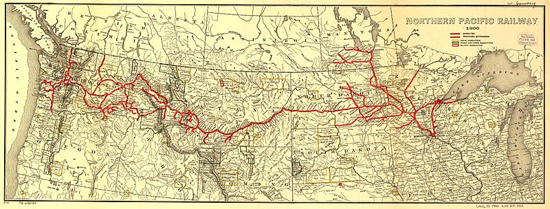
Image: Northern Pacific Railroad map circa 1900

Description: Map showing the en:Northern Pacific Railway route circa 1900.
Title: Northern Pacific Railroad map circa 1900
Credit: Transferred from en.wikipedia to Commons by Ian13 using CommonsHelper. Higher resolution JPEG2000 file obtained from [1] and converted to JPEG.
Author: The original uploader was Slambo at English Wikipedia Later version(s) were uploaded by Ian13 at en.wikipedia. Map created by L.L. Poates Engr'g Co., New York, 1900. Image from the Library of Congress map collection, call number G4126.P3 1900 .L55 RR 502. From Fourth Annual Report of the Northern Pacific Railway company, for the Fiscal Year ending June 30, 1900. Signed in ms: "W. Lowery." Reference: LC Railroad maps, 502. Scale not given.
Permission: "The Library of Congress ... is not aware of any U.S. copyright protection (see Title 17 of the United States Code) or any other restrictions in the Map Collection materials." (Source retrieved 2005-11-29)
Usage Terms: Public domain
License: Public domain
Attribution Required?: No
Image usage
The following page links to this image:
