
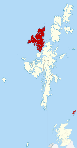
Image: Northmavine Shetland UK parish map (blank)

Size of this PNG preview of this SVG file: 315 × 599 pixels. Other resolution: 126 × 240 pixels.
Original image (SVG file, nominally 832 × 1,582 pixels, file size: 1.5 MB)
Description: Blank map of the Shetland Islands, UK with parishes shown. Equirectangular map projection on WGS 84 datum, with N/S stretched 200% Geographic limits: West: 2.15W East: 0.70W North: 60.88N South: 59.50N
Title: Northmavine Shetland UK parish map (blank)
Credit: File:Shetland_UK_parish_map_(blank).svg
Author: Nilfanion, created using Ordnance Survey data. Northmavine highlighted by Griceylipper
Usage Terms: Creative Commons Attribution-Share Alike 3.0
License: CC BY-SA 3.0
License Link: https://creativecommons.org/licenses/by-sa/3.0
Attribution Required?: Yes
Image usage
The following page links to this image:

All content from Kiddle encyclopedia articles (including the article images and facts) can be freely used under Attribution-ShareAlike license, unless stated otherwise.
.svg)